Attempting to locate an aeroplane's approximate location over Earth when seen from the ground.
15.5.11
Measuring the Solar System
In this lecture, we shall show how the Greeks made the first real measurements of astronomical distances: the size of the earth and the distance to the moon, both determined quite accurately, and the distance to the sun, where their best estimate fell short by a factor of two.
How big is the Earth?
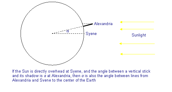
The first reasonably good measurement of the earth’s size was done by Eratosthenes, a Greek who lived in Alexandria, Egypt, in the third century B.C. He knew that far to the south, in the town ofSyene (present-day Aswan, where there is now a huge dam on the Nile) there was a deep well and at midday on June 21, the sunlight reflected off the water far down in this well, something that happened on no other day of the year. The point was that the sun was exactly vertically overhead at that time, and at no other time in the year. Eratosthenes also knew that the sun was never vertically overhead in Alexandria, the closest it got was on June 21, when it was off by an angle he found to be about 7.2 degrees, by measuring the shadow of a vertical stick.
The distance from Alexandria to Syene was measured at 5,000 stades (a stade being 500 feet), almost exactly due south. From this, and the difference in the angle of sunlight at midday on June 21, Eratosthenes was able to figure out how far it would be to go completely around the earth.
How big is the Earth?
The first reasonably good measurement of the earth’s size was done by Eratosthenes, a Greek who lived in Alexandria, Egypt, in the third century B.C. He knew that far to the south, in the town ofSyene (present-day Aswan, where there is now a huge dam on the Nile) there was a deep well and at midday on June 21, the sunlight reflected off the water far down in this well, something that happened on no other day of the year. The point was that the sun was exactly vertically overhead at that time, and at no other time in the year. Eratosthenes also knew that the sun was never vertically overhead in Alexandria, the closest it got was on June 21, when it was off by an angle he found to be about 7.2 degrees, by measuring the shadow of a vertical stick.
The distance from Alexandria to Syene was measured at 5,000 stades (a stade being 500 feet), almost exactly due south. From this, and the difference in the angle of sunlight at midday on June 21, Eratosthenes was able to figure out how far it would be to go completely around the earth.
Continues here.
Separation
In air traffic control, separation is the name for the concept of keeping an aircraft in a minimum distance from another aircraft to reduce the risk of those aircraft colliding, as well as prevent accidents due to wake turbulence.
Air traffic controllers apply rules, known as separation minima to do this. Pairs of aircraft to which these rules have been successfully applied are said to be separated: the risk of these aircraft colliding is therefore remote. If separation is lost between two aircraft, they are said to be in a conflict.
Between the surface and an altitude of 29,000 feet (8,800 m), no aircraft should come closer vertically than 300 metres or 1,000 feet (in those countries that express altitude in feet), unless some form of horizontal separation is provided. Above 29,000 feet (8,800 m) no aircraft shall come closer than 600 m (or 2,000 feet), except in airspace where Reduced Vertical Separation Minima (RVSM) can be applied.
If any two aircraft are separated by less than the vertical separation minimum, then some form of horizontal separation must exist.
Air traffic controllers apply rules, known as separation minima to do this. Pairs of aircraft to which these rules have been successfully applied are said to be separated: the risk of these aircraft colliding is therefore remote. If separation is lost between two aircraft, they are said to be in a conflict.
Vertical separation
Horizontal separation
If any two aircraft are separated by less than the vertical separation minimum, then some form of horizontal separation must exist.
Lunar laser ranging experiment
The ongoing Lunar Laser Ranging Experiment measures the distance between the Earth and the Moon using laser ranging. Lasers on Earth are aimed at retroreflectors planted on the moon during the Apollo program, and the time for the reflected light to return is determined. The distance to the Moon is calculated approximately using this equation:Distance = (Speed of light × Time taken for light to reflect) / 2.
The distance has been measured with increasing accuracy for more than 35 years. The distance continually changes for a number of reasons, but averages about 384,467 kilometers (238,897 miles). The round trip time is about 2½ seconds.
23.1.11
Calculating an aeroplane's altitude
To be able to use trigonometry to locate an aeroplane's position over Earth, two angles and one side of the triangle would be needed. I already have one angle, which is 90°, and I may be able to calculate another using a sextant. The next step would be estimating the aeroplane's altitude. I have found a few suggestions on how to do this.
Quora
Science-Mathematics
Quora
Science-Mathematics
21.1.11
DIY Sextant
http://www.tecepe.com.br/nav/CDSextantProject.

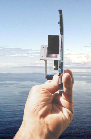
Making my own sextant would possibly mean being able to work out another angle of the triangle, and therefore I would be able to use trigonometry to work out the final angle. Unfortunately, knowing three angles of a triangle does not enable me to work out the three sides, but it is a start.

Making my own sextant would possibly mean being able to work out another angle of the triangle, and therefore I would be able to use trigonometry to work out the final angle. Unfortunately, knowing three angles of a triangle does not enable me to work out the three sides, but it is a start.
Sextant
A sextant is an instrument used to measure the angle between any two visible objects. Its primary use is to determine the angle between a celestial object and the horizon which is known as the altitude. Making this measurement is known as sighting the object, shooting the object, or taking a sight and it is an essential part of celestial navigation. The angle, and the time when it was measured, can be used to calculate a position line on a nautical or aeronautical chart.
Using trigonometry to calculate position
To be able to use trigonometry to work out an aeroplane's location over Earth would involve more than just knowing that there is a 90° angle involved. A second angle would need to be calculated to use this method.
Also, no measurements for the sides of the triangle are known - the distance from the viewer to the aeroplane, the distance from the aeroplane to the ground and the distance from that place on the ground to the viewer. Again, more information is needed.
Subscribe to:
Posts (Atom)


